
Northeast Oregon hides the state's most vertical country. In one compact corner you get "the Oregon Alps" — the granite-and-snow Wallowa Mountains rising out of a green valley to nearly 10,000 ft — and, an hour east, the deepest river gorge in North America. Two wildernesses, two completely different kinds of hard: one you earn on foot because vehicles are banned, the other you reach on long single-lane gravel or by jet boat. This issue is about which trailheads are worth the drive, how not to cook yourself at Hat Point, and where the water and fuel actually are.
The rest of this journal is evergreen; this box is not. Everything below is dated to the day we checked it, and the most perishable items — the road and snow status, the tramway season, the canyon heat — change faster than any printed guide. Trust the procedure and the live sources, not our date stamp.
Most guides to Northeast Oregon pick one story. This corner has two, and they sit an hour apart: the cold, high, glacial Wallowas, and the hot, dry, remote depths of Hells Canyon. Understanding that they are two different kinds of hard is the single most useful thing you can carry into the trip.
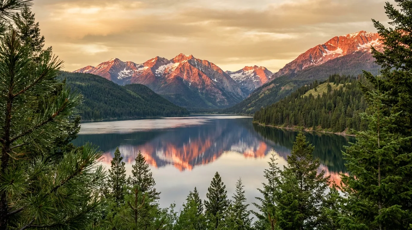
The Wallowa Mountains rise straight out of a green valley to nearly 10,000 ft — Sacajawea Peak at 9,838 ft, the Matterhorn at 9,826 ft, Eagle Cap itself at 9,572 ft. This is granite, alpine lakes and glacial troughs, and you earn every one of them with big elevation gain on foot or horseback, because the Eagle Cap Wilderness bans all vehicles and bikes.
The reward is a chain of turquoise cirque lakes below near-10,000-ft peaks — the closest thing the Pacific Northwest has to the Alps, and far less crowded.
An hour east, the Snake River runs more than a mile below the rim — the deepest river gorge in North America. You earn its rim on long single-lane gravel roads (Hat Point, Buckhorn) and you reach its floor by jet boat or raft from Hells Canyon Dam. There is little shade, little water, and no cell.
Between the two sits the ancestral homeland of the Nez Perce (Nimiipuu) and the frontier arts towns of Joseph and Enterprise — your base, your fuel, and your last water fill.
At the end of OR-82, about 6 to 7 miles south of Joseph, Wallowa Lake is where the trip begins and where the whole region's services concentrate: the state park, the marina, the tramway base and the wilderness trailheads all sit within a mile of each other at the south end.
A glacier-carved lake at 4,372 ft, held in place by textbook lateral and terminal moraines, at the foot of Chief Joseph Mountain. The south end holds the state park and marina; the water is cold year-round. Good for swimming (bracing), paddling, and trout and kokanee fishing, with seasonal boat rentals — rowboats, canoes, kayaks, paddleboats, motorboats — from the marina.
⚠️ State-park water is shut off October through mid-May, and day-use/marina services are seasonal. This is the best family base on the lake — see the camping strategy in §08.
North America's steepest four-person gondola climbs about 3,700 ft from the valley floor to the 8,256-ft summit of Mount Howard. Up top: 2+ miles of easy summit loop trails to viewpoints over the Wallowas, the lake, and on clear days the Seven Devils in Idaho — plus the Summit Alpine Grill, Oregon's highest restaurant.
🔴 Runs late May through early October only, ticket required. It's much colder and windier at the summit — bring a jacket even in July.
This is the reason to come with strong legs. The Eagle Cap Wilderness is the granite heart of the Wallowas — turquoise cirque lakes below near-10,000-ft peaks — and it is foot or stock only. No vehicles, no bikes, no exceptions past the boundary. A free self-issued permit at the trailhead is all the paperwork there is.
| Trail (from) | Distance | Gain | Effort | What you get |
|---|---|---|---|---|
| Ice Lake Wallowa Lake TH | ~7.6 mi one way | ~3,400 ft | Strenuous | A turquoise cirque under the Matterhorn (9,826 ft). Very long day or an overnight; the last miles switchback hard |
| Aneroid Lake Wallowa Lake TH | ~6 mi one way | ~3,000 ft | Strenuous | Sheltered subalpine lake ringed by whitebark pine and historic cabins, via the East Fork Wallowa. A classic first backpack |
| Lakes Basin / Mirror Lake Two Pan TH (Lostine) | ~7 mi one way | ⚠️ verify | Strenuous | The scenic heart of the wilderness — a shelf of alpine lakes directly below Eagle Cap (9,572 ft). Camping restrictions around the lakes |
| West Fork → Six Mile Meadow Wallowa Lake TH | ~5.4 mi round trip | Gentle | Moderate | The valley-bottom option — a good family turnaround or first night's camp before pushing higher. River access for fishing |
| Hurricane Creek → Slick Rock Falls Hurricane Creek TH | ~4 mi round trip | Moderate | Moderate | Quieter valley west of Joseph under Sacajawea Peak (9,838 ft); continues deep toward Echo and Billy Jones lakes |
⚠️ Distance and gain honesty: every figure above is a planning estimate from trail guides and agencies, not GPS-verified — treat one-way vs round-trip labels as approximate and expect variation between sources. The Lakes Basin gain in particular we leave as "verify" rather than print a number we couldn't confirm. Two Pan is at the end of the gravel Lostine River Road; Hurricane Creek and Wallowa Lake trailheads are drivable earlier in the season than the upper trails are clear.
Ice, Aneroid and the Lakes Basin all involve ~3,000+ ft of climbing to 7,500–8,000+ ft. Plan for weather swings and afternoon thunderstorms, and pace your first day up from the valley.
Creek crossings on Hurricane and the West Fork run high and dangerous in spring. The alpine lakes are swimmable in high summer but stay cold — this is snowmelt country.
Because stock travel is allowed, licensed packers run trips into the Eagle Cap — horseback and drop camps from the Wallowa Lake Pack Station, guided llama packing from Wallowa Llamas. A real option if the elevation gain is the barrier.
Two small towns anchor the whole region, and knowing what each one is for saves you a lot of backtracking. This is where you fuel up, fill water, dump tanks, buy a map and eat a real meal before the services run out east of here.
The rule that governs the whole trip: fuel and groceries are scarce east of Joseph. Top off in Joseph or Enterprise, and again in Imnaha.
For gear, Blue Mountain Outfitters in La Grande is the nearest full-line outdoor shop on the way in (backpacking, camping, footwear). In Enterprise, Wallowa County Ace Hardware covers last-minute camp fuel and supplies, and The Bookloft stocks topo and recreation maps and regional guidebooks — worth it, because you should not count on cell navigation east of town.
For an RV dump, water fill and full hookups, Mountain View Motel & RV Park in Joseph is the reliable private option, right before you head into country where dump stations vanish.
The Hells Canyon Scenic Byway is the paved thread that ties the region together. But the signature view — Hat Point, standing more than a mile above the Snake — is not on the pavement. It's at the end of 23 miles of steep single-lane gravel, and getting there is the adventure.
The Hells Canyon Scenic Byway is a 218.4-mile All-American Road — OR-82, OR-350, Forest Roads 39 & 3965, and OR-86 — that encircles the Wallowas and touches the canyon rim. The paved link across the south is Forest Road 39, the "Wallowa Mountain Loop Road," connecting Joseph/Imnaha country with Halfway and OR-86.
⚠️ FR-39 is closed by snow in winter and spring — check its status before planning a loop that depends on it, or you'll be driving the long way around.
On the northern rim, Buckhorn (also Buckhorn Lookout) looks down on the confluence of the Imnaha River and the Snake, reached by long gravel roads across Zumwalt Prairie north of Enterprise (§07). Few people, big view, no fee.
⚠️ The access roads are impassable when wet or snowy, and there are no services. Go in dry conditions, and treat it like Hat Point: fuel, water, spare, and a way to call out that doesn't rely on a cell tower.
If Hat Point is the view from the top, the Snake is the view from the bottom. The floor of Hells Canyon is reached at one place, half a mile below Hells Canyon Dam, where the jet boats and rafts launch onto the deepest river gorge in North America.
The Hells Canyon Creek Visitor Center sits half a mile below the dam, where the boat launch is. It's reached by paved but long, winding roads from Oxbow (about 23 miles) on the Idaho/Oregon line — OR-86, then the Hells Canyon Dam Road. The visitor center is seasonal, and the canyon floor bakes in summer — carry water even for a boat day.
This is the south (dam) end of the canyon — a completely different approach from the Imnaha/Hat Point rim in §05. Don't assume you can cross between them quickly.
Go with a licensed outfitter unless you hold your own permit: Hells Canyon Adventures runs jet-boat tours, raft trips, fishing charters and shuttles from the dam end (family-run since 1973), and Winding Waters River Expeditions out of Joseph runs multi-day rafting and fly-fishing on the Snake, the Grande Ronde and the Salmon.
🔴 Private (non-commercial) powerboat and float trips are permit-controlled via Recreation.gov — if you don't hold a permit, use an outfitter. The jet-boat and raft season peaks May through September.
On the plateau between the Wallowas and Hells Canyon lies something neither alpine nor desert: the largest remaining bunchgrass prairie in the Pacific Northwest, and one of the best raptor-nesting grounds in North America. It's also the gateway to the Buckhorn rim.
The Nature Conservancy protects roughly 51 square miles of native bunchgrass grassland here — the largest remaining stand in the Pacific Northwest. It's day use, foot travel only, on a handful of marked trails from a parking kiosk, and it's known for its hawks, eagles and other raptors. No fee (donations welcome).
Access is by gravel roads north of Enterprise (Crow Creek / Zumwalt-Buckhorn), the same country you cross to reach Buckhorn Overlook. Go in dry conditions — the roads are impassable when wet — and bring water: there is no shade and no water. Best in late spring and early summer when the grass is green and the raptors are nesting.
⚠️ The preserve is an area, not a point — the coordinate in our data is an approximate centroid and is flagged unverified. Navigate to the marked trailhead/kiosk, not a dropped pin.
The camping here splits cleanly by zone: a full-hookup state park at the lake, primitive USFS sites up the gravel trailhead roads, and truly remote, mostly-waterless campgrounds in Hells Canyon and up the Imnaha. Match the campground to where you're actually going, and carry water east of Joseph.
The full-service anchor at the south end of the lake: 209 sites, 121 of them full-hookup, plus yurts, showers and a dump station. $23–$78/night (2026), varying by site type, and open year-round with limited services October to mid-May. It fills in summer — reserve well ahead.
Private overflow / dump & hookups: Mountain View Motel & RV Park in Joseph (20/30/50-amp, water, showers, black-water dump).
Primitive USFS campgrounds string up the gravel Lostine River Road toward the Two Pan trailhead — Williamson, Shady, and Two Pan — plus Hurricane Creek near that trailhead west of Joseph. No hookups, first-come, and a snow-dependent season.
⚠️ Site counts and nightly fees for these are not confirmed on an agency page — we leave them null rather than guess. Confirm at the ranger district before relying on a specific number of sites.
The logistics you sort before you leave Joseph, not after. The two halves of the region open on different schedules, fuel gets scarce fast east of town, and cell service is absent through most of the canyon and wilderness. Here's how to plan around all three.
| Zone | Realistic season | Why |
|---|---|---|
| Wallowa alpine lakes | July – early October | Snow lingers into July and returns in October; trailheads drivable earlier than the upper trails are clear |
| Wallowa Lake Tramway | Late May – early October | Seasonal operation; summit snow-covered otherwise. Ticket required |
| Hells Canyon rim & FR-39 | July – mid-October | Gravel closes with snow and turns to impassable mud when wet |
| Canyon floor / river trips | Spring – fall (peak May–Sep) | Jet-boat and raft season peaks in summer; the floor bakes |
| Best overall window | Mid-July – late September | The overlap where open alpine trails meet open canyon roads |
🔴 Fuel and groceries are scarce east of Joseph. Top off in Joseph or Enterprise before you head toward the canyon, and again in Imnaha, the last reliable fuel and food before the long gravel climb to Hat Point. There is nothing to buy on Hat Point Road, the Buckhorn/Zumwalt roads, or most of the Imnaha corridor — carry what you need.
La Grande (I-84) is the last big-box town on the way in; per our dataset rules we did not record business phone numbers or addresses beyond public listings.
⚠️ Cell service is absent through most of the canyon and wilderness. Download offline maps and buy a paper topo (The Bookloft, Enterprise) before you leave town, and don't count on navigation or a phone call once you're off the highway. This is exactly the terrain where a satellite messenger earns its keep — see §10.
For road conditions, use Oregon 511 / TripCheck and the Wallowa-Whitman NF office (541-426-5546) before you leave signal — not after.
None of this should stop you — all of it should shape how you move. The hazards here are specific: canyon heat with no water, long exposed gravel roads with no services, alpine altitude and cold runoff, and a remoteness that makes any rescue slow. And a gap you should know about up front.
🔴 The Hells Canyon floor and rim routinely bake in summer, with little shade and no water at most sites. Carry far more water than you think you need, avoid midday exertion, and don't underestimate how fast heat drains you at Hat Point or on the river.
🔴 Hat Point (~23 mi) and Buckhorn are steep, single-lane gravel with no guardrails, no services, no cell. Air down and slow down, carry a spare and water, and check road status first — both close with snow and turn to mud when wet.
Ice, Aneroid and the Lakes Basin all climb to 7,500–8,000+ ft — plan for weather swings and afternoon thunderstorms. Wallowa Lake and the high creeks stay cold, and spring runoff makes creek crossings on Hurricane and the West Fork dangerous. And respect the culture: the Wallowa Valley is Nimiipuu homeland and the Old Chief Joseph Gravesite is a sacred site — visit quietly.
Being honest: when we compiled this issue we could not verify an official website for any dedicated towing or 4x4 recovery service in the Wallowa/Hells Canyon area, so we list none. On roads with no services and no cell, a breakdown can mean a very long wait. Carry recovery basics (traction, tow strap, shovel), a satellite messenger, and leave a trip plan with someone. Verify current towing options locally before you rely on any.
Most of this is a normal mountain-and-desert loadout. What's different here comes from four facts: the Eagle Cap is a foot-only, self-permit wilderness; the canyon roads are long gravel with no services or cell; the alpine is high and cold while the canyon is hot and dry; and water and fuel run out east of Joseph.
Built around what's actually open and where the water is: the lake and tramway, the foot-only wilderness, the canyon rim and river, and the loop that ties them together. Each shape names what you must book and what will ruin it.
Run it before you leave. Tap each item as it's done — these are the things specific to the Wallowas and Hells Canyon that a general mountain-trip habit will skip.
Every guide has these. Most don't print them. This is the consolidated list of what we could not stand up and where the numbers you'll see elsewhere come from — because on a trip this remote, a confident wrong number costs more than an admitted gap.
Everything above, condensed into a print-ready PDF built for the glovebox — for country where the cell dies, the water runs out east of Joseph, and there's no local tow truck to call. The two calendars decoded, the foot-only wilderness and its trailheads, the ~23-mile gravel to Hat Point, the jet-boat and raft options on the Snake, the camping strategy across a state park, national forest and Hells Canyon NRA, and the honest list of what nobody could confirm — on paper that works where the signal doesn't.
Every Trekkr Trail Journal is built like this one: custom logistics, honest trail beta, the camping and access detail, kit lists and the local knowledge that turns a good trip into the one your crew talks about for years — including, always, a plain list of what we could not confirm. New destinations drop all season long, from the BC corridors to the Oregon Cascades.
Unlock the Trail Journal Library